Amer Fault surprises geologists
16/07/2012
The study indicated that the fault does not have only one rupture plane, but several, which makes it a highly complex geologic system which continues to have the potential of causing earthquakes. Geologists have located which planes have the greatest seismic possibilities, as well as fractures and areas in which the circulation of endogenous gases are produced and which could have been generated several kilometres underneath.
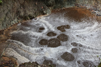
Researchers have analysed the emanation of gases around in the vicinities of an area known as Font Pudosa. “We know that fountains rich in CO2 can be related to fault areas. What is less known is that some of these emanations can include other gases, such as radon and thoron, which can provide information on the seismic potential of these faults”, Mario Zarroca explains.
The research also served to confirm that the fracture known as the "Esquerda de l'Infern" coincides with the line of one main planes of the fault. The most probable hypothesis is that it could form part of the fractures that cross the mountain between Amer and Lloret Salvatge and that, according to historical reports, created an exit for gases and clouds of smoke during the earthquakes of 1427.
“The singularity of these phenomenons confers an additional social value to the research. Their existence helps to 'visualise' and not forget the seismic risks in our territory, in which strong earthquakes can take place after a long time of no activity", Mario Zarroca comments. "That is why it is important to study seismic activity indicators which allow to obtain information on where and when they may take place."
The methodology geologists applied in this study is pioneer in its field and can be used in many other important areas. Researchers also proposed a conceptual model on how subterranean water and gases interact, travel and disperse within the system formed by the mountain, fault and the valley region. “Since it is so general, this model is easy to export to many other regions of the world”, Mario Zarroca concludes.
The fault segments under study form part of the Amer-Brugent Fault, which controls the deepening of the Empordà graben and is also related to the volcanic landscape of La Garrotxa. Given its context within tectonic earthquakes, the fault is considered one of the most potentially active earthquake zones in the Iberian Peninsula, alongside parts of Murcia and Andalusia.
Image: Emanation of endogenous gases (CO2, radon and thoron) at Amer is highly visible in areas where water accumulates as, for example, after a rainstorm.