The most complete satellite image server of Catalonia, SatCat, is born

17/02/2012
Can the urban development experienced in the past few years be seen? What did Barcelona's coastline look like 40 years ago? The Server of Satellite Images of Catalonia, SatCat, offers a surprising and never before seen view of the history of our territory. The slow changes taking place in the deltas, the course of rivers or burning woodlands, which are often overlooked by the human eye, have been recorded from space and are now available for the public.
SatCat has gathered images and now offers the public hundreds of images of the Catalan territory made by the Landsat satellites from 1972 to 2011. This is a pioneer initiative in Spain and was created by the Research Group of Methods and Applications in Remote Sensing and Geographical Information Systems (GRUMETS). In the past years, GRUMETS has organised and fed into the server all images of Catalonia taken by the most important satellite in the world dedicated to observing Earth at a detailed scale, the Landsat. The objective is to offer free access to all the information gathered. With this initiative, SatCat has been able to adapt to the vertiginous speed at which data is captured by the satellite and has contributed to what is known as "the petapixel revolution" provided by remote sensing, where scientists work with trillions of pixels, the largest amount of data humanity has ever had on one sole theme.
“These images will be very useful to the administration, to researchers and to businesses since they allow to study visually the changes taking place in the region in the past years. It is also of great interest school-wise. The tool can be consulted online and this will help schools and universities understand many issues related to the landscape and history of the region", says Xavier Pons, UAB professor in Geography and coordinator of the research group GRUMETS.
The SatCat server provides both historical and recent images which can be easily compared. Thus changes in one same region can be observed as in a film. It also offers the option of downloading images and using them professionally in remote sensing tasks. All images can be seen in natural and in false colour (where details can be better appreciated) and users can zoom in to observe a particular area and even move the image around. Each image includes standardised metadata (complete technical information of the date, time, characteristics of the sensor, etc.).
All treatment of the images, as well as server and internet navigator, were carried out using the MiraMon software, a powerful program developed in Catalonia since 1994 by the research group. The software is used in 29 different countries and received an international prize in 2000.
Born under the initiative of the Centre for Environmental Documentation of the Generalitat in 2004, the server has grown with the addition of hundreds of historical images. It can now be consulted online at the following website: http://opengis.uab.cat/wms/satcat/index.htm
The SatCat reconstructs and analyses the most emblematic historical changes occurring in Catalonia. The list of areas where this database can be applied is as diverse as the territory and its history in the past 40 years. Some examples worth highlighting are:
• The dynamics of the delta of the river Ebre, in which viewers can observe interannual cycles of rice fields and changes in the coastline, which has retroceded 0.7 km in the past few years.
• Changes in reservoir levels at Sau-Susqueda or Boadella.
• Images of before and after the construction of the Rialb dam.
• The dynamics of parts of the delta of the river Llobregat, with the construction of the third airport runway, the diversion of the river and the enlargement of the harbour, the Olympic channel, etc.
• Forest fires and their impact on the territory
• Observation of urban growth.
• Studying snowmelts as a source for determining water balance.
• Studying the construction process of large infrastructures such as motorways and the high-speed rail.
• Observing changes occurring to the territory due to land used for quarries.
• Observing with more spatial detail than conventional meteorological satellites weather phenomena such as dense fog in the interior of the country.
Leaders in remote sensing research
The group GRUMETS (Research Group of Methods and Applications in Remote Sensing and Geographical Information Systems) is a consolidated research group, financed by the Government of Catalonia and formed by UAB and CREAF members. The group is directed by Xavier Pons, professor of the Department of Geography. Members have worked in the field of remote sensing since the end of the 1980s, and collaborate with leading institutes such as the Institute of Cartography of Catalonia (ICC), the National Geographic Institute (IGN), the European Space Agency (ESA), etc.
GRUMETS has participated in several applied projects; one of the most outstanding of these was the management of water of Catalonia through remote sensing, which won the group the 2007 Environmental Prize and was carried out jointly with the Government of Catalonia. In terms of research, the group has participated in international projects such as Geo-Pictures, aimed at providing images of humanitarian emergency situations in which communication networks do not function properly, and GeoViQua, aimed as visualising and parametrisation of the quality of geographic data. The project was led by GRUMETS and included the participation of the European Space Agency.
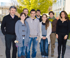
Image: Members of the Research Group of Methods and Applications in Remote Sensing and Geographical Information Systems (GRUMETS) develop SatCat, coordinated by UAB professor in Geography Xavier Pons (first from left).