New Cartography of Ecosystem Services for Barcelona
18/04/2016
The Institute of Environmental Science and Technology (ICTA-UAB), CREAF and the Barcelona Provincial Council have developed and published the first phase of the Cartography of Ecosystem Services for the province of Barcelona. The new product is composed of a number of digital maps that identify and quantify the ecosystem services of the province, such as food production, capture of carbon dioxide and leisure opportunities, in natural and rural spaces. The cartography is available via SITxell and aims to identify the function of the Ecosystem Services as elements which support people’s quality of life directly or indirectly.
The ecosystem services are classified into four broad categories: Provisioning services, Regulating services, Habitat or supporting services and Cultural services. They are related to the main components of human well-being, which are health, security, basic material goods and good social relationships.
In Barcelona, the ecosystems are mainly forestry –forests, shrublands and meadows- and agricultural. Also highlighted should be the urban ecosystems related to urbanization processes such as parks and gardens, particularly present in the metropolitan area of Barcelona.
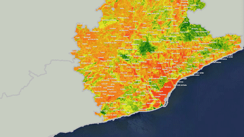
Thanks to these maps it will be possible to determine with unprecedented precision what areas of the territory may offer more or less services. It will be also possible to identify specific benefits provided to the population, including erosion control, provision of food and wood, or capture of atmospheric CO2: in other words, services which support people’s health, quality of life, and the economy.
The Cartography has enabled the combination of information on an array of ecosystem services at a high level of detail in a homogeneous manner for the whole province of Barcelona. The high resolution of the maps is notable: for each pixel, equivalent to the size of a football field (100 x 100 meters), there is a value stored for a given ecosystem service.
The first nine maps are available in digital format through the map server SITMUN of the Diputació de Barcelona. New cartography will be distributed through the same technical platform.
This information will help cities and other local administrations to plan and manage the territory by using tools such as Urban Organization Plans.
In the case of the province of Barcelona, it is hoped that this will further the development of a model of a green infrastructure network consisting of open spaces combining biodiversity protection and the provision of ecosystem services to the population.
The initiative has been underway since 2014 in conjunction with the Forest Technology Centre of Catalonia (CTFC), the Catalan Institute of Ornithology and the Unió de Pagesos (Farmers Union).
ICTA-UAB researchers involved in the project are Francesc Baró, Johannes Langemeyer and Erik Gómez-Baggethun, who are members of the research group Laboratory for the Analysis of Socio-Ecological Systems in a Global World (LASEG).