

Spatial Dynamics of Catalonia's Population since 1980
In the early 1980s, the Generalitat of Catalonia, the Catalan Autonomous Government, developed a territorial plan, the General Spatial Planning of Catalonia (GSPC), approved in 1995. The main aims of the GSPC were to achieve a more balanced distribution of population, avoiding the congestion of the Barcelona metropolitan region, coastal overcrowding and depopulation of mountain areas, and to improve mobility infrastructures and social welfare.
After almost 20 years of its approval, a protocol was applied to evaluate the spatial and socio-environmental consequences of this regional planning using the data from the 946 Catalan municipalities. The methodology used was based on principal component analysis (PCA) with the objective to reduce 30 socioeconomic and geographical variables, extracted from different sources, in a lower number of PCs. Three periods of time were analysed: 1980s, early 2000s and 2009, and six PCs were retained for each period, explaining 82.6% of total variance. These PCs showed some clear dynamics as in PC number one, labelled as “urbanization”, which included economic activities associated to those areas more urbanized and populated, or in PC number six, labelled as “tourism”, linked to hotel and camping capacities and secondary residences.
In order to synthesize the 18 PCs obtained, a clustering technique was applied with the objective to group those municipalities with the same dynamics. Six final clusters were retained and labelled as “municipalities specialized in tourism”, “rural municipalities with some tourism activities”, “irrigation agriculture without tourism activities”, “dry agriculture without increased urbanisation and tourism”, “pastures and forest land”, and, finally, “municipalities without changes”.
Figure 1: Final results from clustering analysis.
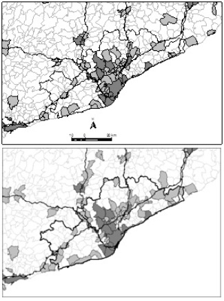
Our results showed the spatial dynamics from the 1980s, essentially summarizing three situations: decongestion, depopulation and coastalisation. The decongestion of Barcelona has produced an increase of urban sprawl around the Metropolitan Region, producing increments of mobility and aggravating the dependency of private cars, and, in consequence, causing more atmospheric pollution. Although the rise of some re-territorialisation processes linked to protected areas and tourism activities, depopulation mainly occurred in the Catalan Pyrenees and in some inland municipalities with a high presence of dry farming, producing agricultural abandonment and increasing vulnerability to extensive wildfires. Finally, the process of concentrating population and economic activities in coastal spaces has produced excessive congestion, landscape degradation and more risk to floods.
Top left figure: Dynamics from 1980s (top) to 2009 (down) around the Metropolitan Region of Barcelona.
References
Serra, P.; Vera, A.; Tulla, A. F. Spatial dynamics of Catalan regional planning: a multivariate statistical analysis of 1980s and 2000s data. European Planning Studies. 2014, vol. 22, num. 6, p. 1280-1300. doi: 10.1080/09654313.2013.782388.