

What can we do to protect the rural land surrounding big cities?
In the last 50 years, approximately, due to the intense processes of urbanization, in many cases in a discontinuous and dispersed way, the traditional clear cut division between urban and rural land has lost relevance, producing fragmented landscapes and transition zones between the city and the countryside with a mix of heterogeneous land-uses, including agriculture. The emergence of new functions for peri-urban agriculture (PUA) is a typical result of such transformations. In consequence, PUA is a type of productive farming of interest for urban planning due to its recognized economic, environmental and social functions. However, information gaps still exists and comparative analyses are needed to relate farm dynamics with fringe landscape modifications in different socioeconomic contexts.
Therefore, the purpose of this study is to contribute to the analysis of PUA systems in developed countries by proposing a quantitative approach to profile farm types and related landscape structure. The study area corresponded to the now extinct Environmental Authority of the Metropolitan Area of Barcelona (EAMAB), including 33 municipalities around Barcelona city and covering an area of 587 km2 with a population of 3.2 million. This methodology may contribute to designing more effective measures for the conservation of agriculture related activities under urban containment and sustainable development strategies.
After a brief historical analysis of PUA in the study area, our quantitative approach consists of three steps: (i) A multivariate statistical analysis at the municipality scale combining data from multiple sources which allowed the analysis of PUA dynamics (between 1960 and 2010) according to official statistics using, for instance, population data or number of farms. (ii) A quantitative landscape structure and composition analysis based on selected spatial metrics of land use, with the objective to verify land cover and landscape changes and the distinctive fragmentation of former rural lands. (iii) The characterisation of homogeneous agricultural typologies according to the following specific indicators: socio-demographic profile of farmers, economic viability, socio-environmental functions and landscape preservation.
The five PUA typologies identified in this work (Baix Llobregat agricultural park, farming in forest areas, cereal monoculture, farming in natural protected areas, and marginal orchards) are the remnants of historical agricultural activity that maintain a significant social, cultural and environmental heritage and that require conservation. According to our final territorial analysis, the Baix Llobregat agricultural park would be the main area to protect, given its high socio-economic, environmental and traditional landscape values. The rest of the PUA typologies may be also important to maintain biodiversity and traditional landscapes, to act as green corridors and finally, to sustain social and leisure activities, among other functions. Therefore, improved preservation is crucial in order to avoid more urban sprawl and the total disappearance of farming in the EAMAB. Our study, consequently, reinforces the idea of creating a polycentric functional ecological network of all PUA typologies integrated with natural vegetation.
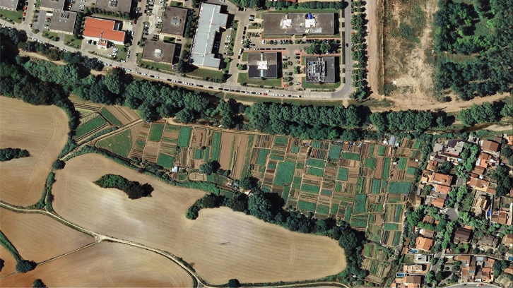
Figure shows some spatial locations of the five distinctive PUA typologies and the final proposed polycentric functional ecological network.
Figure. Fragments of ortophotos representative of each PUA typology. Figure a. A section of the Baix Llobregat Agricultural Park, between el Prat del Llobregat and Sant Boi de Llobregat. Figure b. An example of dry plum trees in a forest area. Figure c. An example of cereal fields close to Cerdanyola del Vallès city. Figure d. An example of vineyard fields in Collserola Natural Park. Figure e. An example of marginal orchards in Cerdanyola del Vallès municipality. Source: Institut Cartogràfic i Geològic de Catalunya (ICGC). Figure f. Map of the final proposal: polycentric functional network of the five PUA typologies integrating with corridors (forest and agriculture land). Priority places to consider in the proposal are indicated by arrows. Location of each PUA typology fragment shown above (a, b, c, d and e) is highlighted. Source: own elaboration.
Human Geography Area
Universitat Autònoma de Barcelona
References
Pere Serra, David Saurí & Luca Salvati. Peri-urban agriculture in Barcelona: outlining landscape dynamics vis à vis socio-environmental functions. Landscape Research,2017 DOI: 10.1080/01426397.2017.1336758