At the limits of a tsunami: prehistoric archeology in northern Scotland
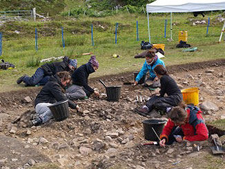
Throughout July, seven undergraduate archaeology students from the UAB (Laia Catarineu, Mireia del Pueblo, Anna Franch, Laura Juanola, Monica A. Lozano, Eva Ros and Nadia Tarifa) have been learning field and laboratory research skills under the direction of UAB professors Karen Hardy (ICREA professor) and Manuela Perez, at the Mesolithic site of Camas Daraich, in the southern tip of the Isle of Skye (NW Scotland).
This site represents one of the best preserved Mesolithic settlements in the west of Scotland and only the second in Scotland with evidence for a circular structure or hut (the other is at East Barns, near Dunbar in southeast Scotland). Camas Daraich dates to a time when Britain was still a part of continental Europe and it is revealing new perspectives on the early people in this region.
Camas Daraich was discovered in 2000, as prehistoric stone tools and waste material were uncovered when a track was being opened in this remote rural area (Hardy and Wickham-Jones, 2004). In 2008 the UAB took up this research initially with a Batista and Roca project: "Archaeology of Coastal Resources on the West Coast of Scotland" and a more recent I+D (research and development) project, Ministry of Science and Innovation (HAR2009-07123). The new excavations, which occurred between 2010 and 2012, covered a much wider area and revealed the remains of a hut, hearths and thousands of worked pieces of stone. The analysis of the excavation and excavated material will reveal insights into domestic activities undertaken in the settlement, while the abundant remains of charcoal will provide information on aspects of diet and paleoenvironment. The site was radiocarbon dated to the mid seventh millennium BC. This corresponds to the early Mesolithic of Scotland, a time that is still poorly understood.
Camas Daraich is interesting because it provides an important geographical link between the island of Rùm to the south (where the remains of another Mesolithic settlement were excavated in the 1980’s) and the Inner Sound, a strait to the north, where the ‘Scotland’s First Settlers’ project revealed extensive evidence for Mesolithic occupation (Hardy and Wickham-Jones, 2002, 2003, 2009).
Camas Daraich is located near the most southerly tip of the Sleat peninisula, 500m north of a small white-sandy bay on a rocky coastline. It is located between two small hills and lies on top of an ancient paleo-beach which is today more than 20 m above sea level. A shallow basin lies a small distance to the north; this was alternately a freshwater lagoon and a small bay marine inlet at different times in the past. Survey work in 2012 on the margins of the basin have revealed possible traces of the prehistoric Storegga tsunami, one of the most important tsunamis to be documented in the North Atlantic with waves that could have reached over 20 metres in some areas. The tsunami occurred 7500 years ago, almost at the same time as Camas Daraich was occupied. If confirmed, this would be the first time that this phenomenon is identified on the west coast of the United Kingdom, far from the epicentre.
The research is also exploring the development of new techniques and the application of new field work technologies, including use of digital images and GIS development recording of the archaeological excavations. This detailed recording system will allow a more reliable reconstruction of the archaeological levels and will form the basis for spatial analysis to determine the different activity areas both inside and outside the Mesolithic hut.