Over 300 archaeological vestiges registered at the National Park of Aigüestortes
11/07/2016
A team of researchers led by the Universitat Autònoma de Barcelona (UAB) has identified a total of 344 archaeological vestiges at the Aigüestortes and Lake Sant Maurici National Park (PNAESM), making it one of the mountainous regions in Europe with the greatest amount of documented registries.
The data is the result of a mountain archaeology research programme commissioned by the National Park's management board for a ten-year period (2004-2014) and which incorporated the study of systematic surface prospecting into its methodology.
The suitability of including this methodology into traditional archaeological and palaeoecological research conducted in high mountain regions and the results obtained are explained in an article published in Quaternary International, in which the authors also detailed the work carried out and discoveries made in over a decade.
“Our knowledge of the historic and archaeological past of the park has radically changed now that we have discovered a humanised territory difficult to imagine a few years back. In 2001, there was no archaeological registry of the areas studied, we only knew of a few vestiges cattle raisers had mentioned to us. What we now have contradicts our perception of mountain regions as natural reserves, protected from human interventions," the authors of the article state.
“The research at the same time confirms that most registries can be found above the forest's current treeline, within or very close to pastures. This phenomenon reaffirms the relation between human occupation of the territory and cattle raising practices, and at the same time points to the question of how responsible humans are for the pastures currently existing at more than 2,200 metres above sea level”, explains Ermengol Gassiot, lecturer at the Department of Prehistory and Director of the High Mountain Archaeology Group, coordinator of the project.
Tracking the Park
To detect these remains, especially at more than 2,000 metres, researchers tracked the surface of the park by dividing it into trans-sections and at the same time using remote detection systems (LIDAR), orthophoto mapping and aerial photography. The data obtained was entered into a geographic information system of the national park's archaeological heritage, making its management and analysis much easier.
That allowed them to have a more general perspective on the spatial dimensions of the social practices existing and predict activity patterns through time. It also enabled researchers to propose a new definition, interpretation and documentation of the identified vestiges, which mainly include architectonic remains, but also shelters, mounds and isolated objects such as flint knives and ceramic recipients.
The majority of sites identified (221) are open-air architectonic remains: walls, enclosures of different sizes and purposes, and possible living structures, many of which were interrelated and formed complex settlements. The rest of them are shelters which made use of large rock formations from the glacial period as distribution walls or to protect entrances. Finally, a small set of stone circles possibly representing funerary monuments was also found, although none have been excavated yet.
The vestiges are located mainly in the glacial circles and in the secondary valleys of the park, close to streams, rivers and lakes, mainly in the areas of pastures and meadows.
High Areas and Screes
Researchers were surprised by the fact that most remains are located in higher altitudes. A total of 165 are located between 2,200 and 2,400 metres above sea level, an altitude comprising only 25% of the park; while between 2,400 and 2,600 metres, comprising 27% of the park, researchers found 69 vestiges. Ten more were found above 2,600 metres. The remains discovered at the highest altitudes are no smaller or less important than those lower down the mountain, contrary to what could be theoretically expected, since humans tended to inhabit valleys and due to the greater difficulty to transport goods.
Another surprising element is the presence of up to 69 sites, often of large dimensions and some used during different periods, located near screes, a type of terrain which at first seems unsuitable for human settlement and which now are considered to be an area of archaeological interest.
Continuous Occupations
Throughout the ten years, researchers conducted 76 radiocarbon dating of 39 sites, making the national park one of the areas with the greatest amount of detailed chronological information of the Pyrenees and also of the mountains of Europe. In total, the information registered suggests that there has been continuous human occupation for some 10,700 years.
Worth highlighting is the elevated presence of sites from the end of the Neolithic period, between 3400 and 2300 BCE, while in the following 2000 years (from 2300 to 300 BCE), during the Bronze and Iron Ages, a notable reduction is detected. The only archaeological evidence from this period consists in deposits of different types of ceramic materials from the second millennium BCE, and also possible tombs.
This data contradicts the palaeoenvironmental registries (pollen or carbon) which were discovered from the same period in other alpine and subalpine areas in the vicinity of the park and which reveal an increase in human impact on plants in this period. That has made researchers think that even if there was no abandonment of the territory, there must have been a change in settlement patterns between the two periods. At the PNAESM, the rock shelters were abandoned, perhaps in favour of larger open-air settlements, although this could not be detected archaeologically. The absence of surface prospecting at lower altitudes, such as in the mountain ranges outside of the park or in the pre-Pyrenees valleys of the rivers Noguera Pallaresa and Noguera Ribagorçana, makes it difficult to compare the two areas in order to evaluate whether or not this apparent emptiness was a local phenomenon.
“The presence of archaeological registries of later periods progressively increases, especially between the 4th and 14th centuries CE, and then again decrease at the beginning of the 20th century. Many of the sites were occupied throughout the different periods, which demonstrates the territory is important to the social and economic dynamics of the area, from prehistoric times up to the present day”, Ermengol Gassiot points out.
Expanding into the Aragonese Pyrenees
The research will continue to expand the number and extension of the excavations and cover some of the remaining areas, which will probably represent a growth in the number of vestiges discovered until now. At the same time, researchers have broadened the study of surface prospecting to include the Aragonese Pyrenees and in all probabilities will do the same with Andorra.
According to the scientists, the new techniques used in prospecting studies are proving to be essential in research conducted at high altitudes and are demonstrating that areas considered marginal to archaeological research are not that difficult to access.
Participating in the research, in addition to researchers from the UAB departments of Prehistory, Geography, and Animal Biology, Plant Biology and Ecology, were researchers from the Institución Milá y Fontanals (IMF-CSIC) and from the National Center for Scientific Research (CNRS).
Article: Surface Surveying in High Mountain Areas, Is It Possible? Some Methodological Considerations. Ermengol Gassiot Ballbè, Ignacio Clemente Conte, Niccolò Mazzucco, David Garcia Casas, Laura Obea Gómez, David Rodríguez Antón. Quaternary International. Volume 402, 26 May 2016, Pages 35–45. DOI: 10.1016/j.quaint.2015.09.103
Images by High Mountain Archaeology Group, UAB:
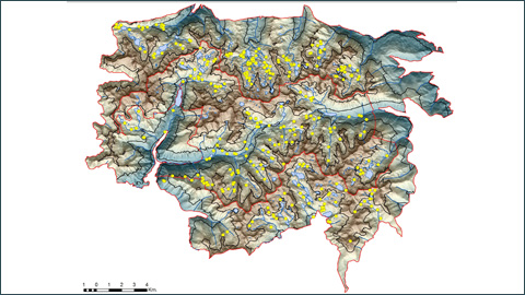
http://www.uab.cat/uabdivulga/img/UAB_PNAESM1.jpg
Map of the Aigüestortes and Lake Sant Maurici National Park with archaeological vestiges documented since 2004.
http://www.uab.cat/uabdivulga/img/UAB_PNAESM2.jpg
Example of orthoreferencing of archaeological vestiges using aerial photos. In the image, the remains of a cattle farm from the 18th-19th centuries.
http://www.uab.cat/uabdivulga/img/UAB_PNAESM3.jpg
Abric de les Obagues de Ratera at more than 2,300 metres above sea level. This is an example of a small rocky shelter with human activity since the end of the Neolithic period (2800-2600 BCE) up to modern days. Currently undergoing an excavation process by the UAB High Mountain Archaeology Group.
http://www.uab.cat/uabdivulga/img/UAB_PNAESM4.jpg
Crest between 2,700 and 2,800 metres to the east of the Pic de la Mainera. Prehistoric flint tool remains were discovered in the areas marked with numbers.
http://www.uab.cat/uabdivulga/img/UAB_PNAESM5.jpg
Image of part of an enclosure, cabins and other constructions making up the Despoblat de Casesnoves, situated in a moraine within a scree area at 2,225m above sea level.
http://www.uab.cat/uabdivulga/img/UAB_PNAESM6.jpg
Detail of a ceramic recipient from some 4,000 to 3,000 years ago (Bronze Age) found near a scree in 2004.